
Douay Gold Project (50/50 JV)
Overview & Highlights
- Owned by 50/50 Joint Venture between Maple Gold and Agnico Eagle Mines Limited
- Located in one of the world’s best mining jurisdictions
- Established gold resource – SLR March 2022
- Virtually royalty free (just 1% NSR to IAMGOLD covering only 11.9 km2 of the property) and 2% NSR to Maple Gold
- Excellent infrastructure and large operating mines in the region
- District-scale ~357km2 property with significant resource expansion and discovery potential
Location & Jurisdiction
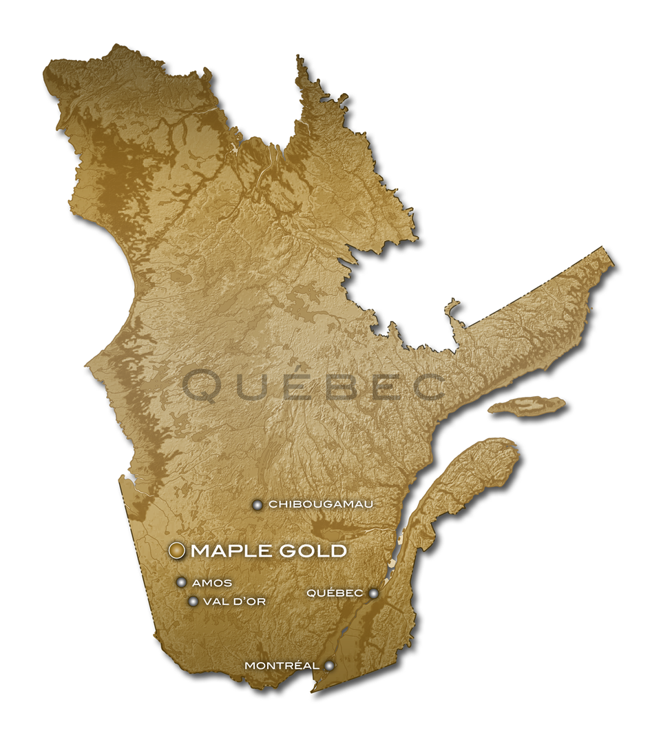
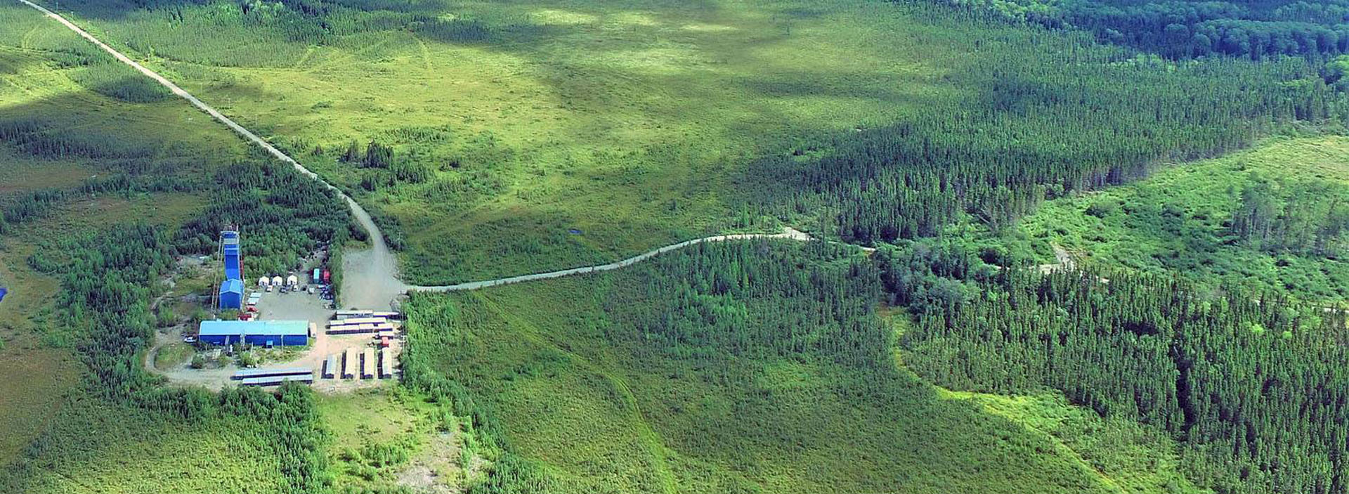
The Douay Gold Project is located in Quebec, Canada, approximately 2.5 hour drive north of Val d’Or and 1.25 hours north of Amos via Highway 109. The pre-existing facilities are accessible via gravel road less than 10 minutes from the main highway, while a new 46-person camp has been built just west of the highway.
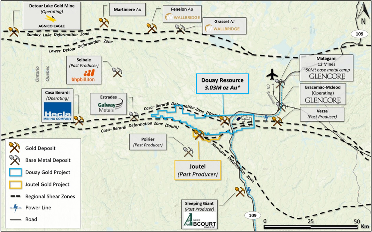
Quebec is renowned for its mineral content and has a total area of 1.7 million km2, of which only 1% is mined and only 5% is covered by mining rights. It is the second largest gold producing province in Canada and hosts some of the largest mining operations in the country, including the geologically similar Canadian Malartic mine. Canadian Malartic is jointly operated by Agnico Eagle Mines and Yamana Gold and is located 150 km south of the Douay Gold Project.
Consistently ranked amongst the top 10 mining jurisdictions in the world by the Fraser Institute’s Annual Survey of Mining Company, Quebec offers a number of competitive tax incentives created specifically for mineral exploration and development companies. For example, for every $1 in exploration spent, companies may receive up to $0.37 back in tax credits.
Infrastructure
The project benefits from existing infrastructure, which includes:
- Major provincial Hwy 109 leads to and cuts across the Project
- Hydro-Powerline (Powerline 6) currently runs right through the Project
- Full-service 46-person camp in place just west of highway 109
- Core logging & storage facilities
- Rail & Air within 55km (Matagami)
Project Geology & Mineralization
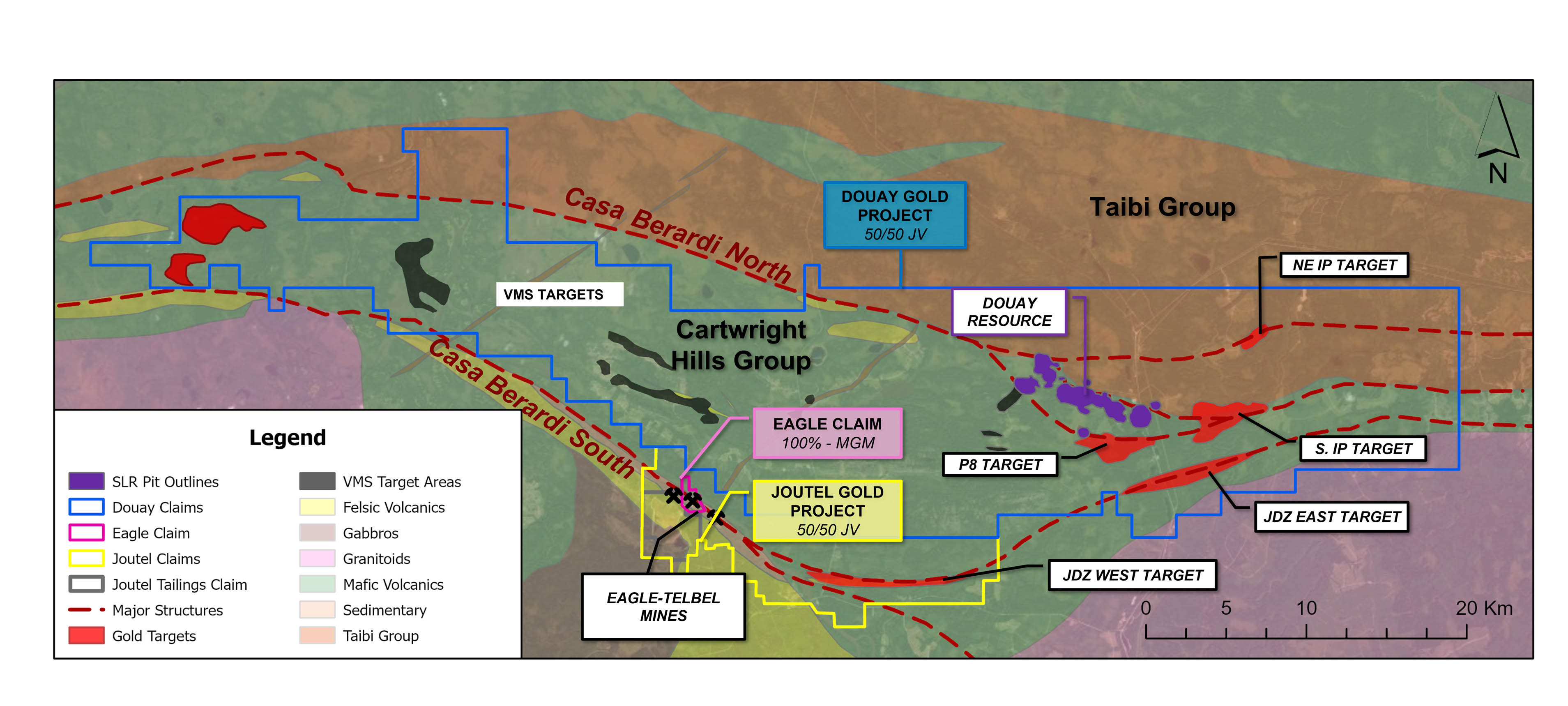
The Douay Gold Project covers an area of more than ~357km² along the Casa Berardi Deformation Zone (“CBDZ”) within the prolific Abitibi Greenstone Belt (“AGB”). Douay belongs to the alkaline-intrusive-associated gold class of mineral deposits, which includes Beatty (>5.6Moz Au), Holt-McDermott (>1.3Moz Au), and Canadian Malartic (>17Moz Au) in the AGB. The area is also prospective for the more typical AGB orogenic style (structurally controlled gold-quartz veins and veinlets) of gold deposit as well as for volcanogenic massive sulphide (“VMS”) deposits.
The Douay project is underlain by a northern assemblage of mafic and felsic pyroclastic and sedimentary rocks (Taïbi Grp), a central assemblage consisting of basalts, co-genetic gabbros with lesser felsic volcanic rocks (Cartwright Hills Grp) intruded by the 6.5 x 2km Douay alkaline intrusive complex (syenite to monzonite, alkali gabbro and carbonatite) with its associated gold mineralization; and a southern assemblage consisting mostly of basalts (also Cartwright Hills Grp) with siliceous-chemical sediments and chlorite-sulphide alteration zones that may be associated with VMS style of mineralization. The volcanic stratigraphy strikes WNW to ESE whereas the major regional fault zones trend E-W or NW-SE. Existing drill data shows multiple higher-grade zones, including Douay West, within and near the Douay intrusive complex. In addition, there are further underexplored known and possible syenitic bodies elsewhere on the property.
Fe-carbonate-albite-pyrite alteration assemblages may be associated with higher gold values, generally above 5 g/t gold. Fractured syenite containing irregular fine pyrite veinlets in addition to disseminated pyrite, encompassing altered basalt fragments and magnetite-rich zones typically yields 0.1 to 1.5 g/t gold or more over intervals from tens of metres to over 150m.
Gold mineralization appears to be associated with the following features:
- Proximity of a major fault to provide a plumbing system and structural permeability.
- Interlayering of different lithological units, especially mafic with felsic units with syenitic intrusions. These are thought to provide rheological contrasts to focus deformation, alteration and mineralization.
- The presence of chemically favourable mafic units providing iron for sulphidation of mafic minerals.
- The presence (for proximal style of mineralisation) or nearby (for more distal style) syenitic intrusions, as bodies, dyke swarms or narrow injections, interpreted to represent the source of metals and sulphur.
- Sulphides averaging 2% but varying from trace to 5%.
Resource Estimate
The Douay Gold Project has an established National Instrument 43-101 mineral resource estimate of 10.0 million tonnes grading 1.59 g/t Au for 511,000 contained ounces of gold in the Indicated category and 76.7 million tonnes grading 1.02 g/t Au for 2.53 million contained ounces of gold in the Inferred category using a cut-off grade of 0.45 g/t Au for open-pit Mineral resources and a cut-off grade of 1.15 g/t Au for underground Mineral Resources. Further information about key assumptions, parameters and methods used to estimate the mineral resources, as well as legal, political, environmental or other risks that may affect the mineral resource estimate are included in the NI 43-101 Technical Report. See table below for a detailed breakdown:
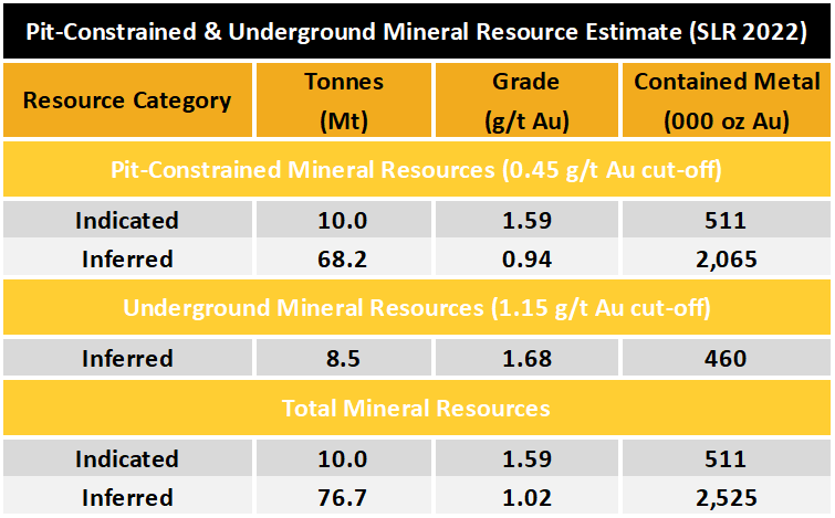
Notes:
- The 2022 MRE is compliant with Canadian Institute of Mining, Metallurgy and Petroleum ("CIM") Definition Standards (2014) incorporated by reference in National Instrument 43-101. The effective date for the Resource Estimate is March 17, 2022.
- Pit-constrained Mineral Resources are reported above a cut-off grade of 0.45 grams ("g") per tonne ("t") of gold ("Au") and underground Mineral Resources are reported with constraining shapes which were generated using a 1.15 g/t Au cut-off value and include low grade blocks falling within the mineable shapes.
- Pit-constrained Mineral Resources are reported within a preliminary pit shell using assumed mining costs of C$3.00/t mined (rock) and C$2.30/t mined (overburden), processing cost of C$9.10/t milled, G&A cost of C$2.70/t milled, and gold recovery of 90%.
- The Whittle pit shell used to estimate Mineral Resources used a long-term gold price of US$1,800 per ounce and a US$/C$ exchange rate of 0.80. However, the implied gold price for the Mineral Resources reported at the applied cut-off grade of 0.45 g/t would be significantly lower.
- Mineral Resources located outside the pit shell were reported on the basis of a potential underground mining operation at a gold cut-off grade of 1.15 g/t Au. This cut-off grade was based on mining costs of C$63/t and the same processing and G&A cost assumptions listed above.
- A minimum mining width of 3 metres ("m") was applied to the Mineral Resource wireframes.
- Bulk density was interpolated for Nika, Porphyry, and 531 zones on a block per block basis using assayed values. For all other zones, bulk density ranging between 2.72 t/m3 and 2.88 t/m3 was assigned to Mineral Resources based on the zone.
- Numbers may not add due to rounding.
JV Partnership & Exploration Potential
As per a joint venture Definitive Agreement signed on February 2, 2021, Agnico would provide a total of C$18 million of funding over four years for exploration expenditures at the Douay and Joutel properties, which will be allocated based on management committee budgets. Agnico and Maple Gold will contribute proportionately for expenditures thereafter.
Other terms of the joint venture include:
- Maple Gold’s exploration team will be supported by Agnico Eagle’s top-tier technical team which has vast experience and knowledge of the Abitibi as well as access to best-in-class software and tools.
- Agnico and Maple Gold will jointly fund an additional C$500,000 in exploration of VMS targets located on the western portion of the Douay Project.
- Agnico to support Maple Gold in its pursuit of third-party project financing for the development phase; and
- Maple Gold retains a 2% NSR on the Douay property with aggregate buyback provisions of C$40 million.
The Douay Project resource remains open in multiple directions laterally with significant resource expansion potential. Significant drill gaps of hundreds of metres remain throughout the 6-by-2 km resource area, with many areas in and around the resource underexplored. Maple Gold and Agnico share a common vision for realizing the exploration potential at the Douay God Project. With close collaboration and by employing modern approaches to exploration, management believes there is strong potential for expanded mineral resources and new gold discoveries across the district-scale property package.
Underground Exploration Potential*
The resource is also open at depth, with known higher-grade zones open down plunge and the vertical depth of all drilling at Douay averaging only 350 metres. Figure 2 shows the SLR underground reporting shapes in pink (460,000 Inferred ounces averaging 1.68 g/t Au), as well as the mineralized blocks at various grades below the pit shells that were not included in the reporting shapes, therefore, not reported in the current Mineral Resource statement, due to insufficient drilling.
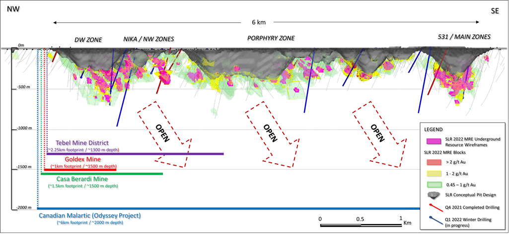
Figure 2: NW-SE longitudinal section showing distribution of below-pit-shell underground blocks and resource expansion potential at depth. Other mine/project information is shown for reference only.
*The potential quantity and grade are conceptual in nature as there has been insufficient exploration to define a Mineral Resource along strike from the resource area, and it is uncertain if further exploration will result in the target being delineated as a Mineral Resource. The underground exploration potential estimated outside of the resource reporting pit shell is based on areas of mineralisation intersected by drilling, but not necessarily supported by two drill holes, which was required for Inferred Mineral Resources, plus the immediate down-plunge extension of known zones of mineralisation.
Qualified Persons
The Mineral Resources disclosed on this page have been estimated by Ms. Marie-Christine Gosselin, P.Geo., an employee of SLR and independent of Maple Gold Mines. By virtue of her education and relevant experience, Ms. Gosselin is a "Qualified Person" for the purpose of NI 43-101. The Mineral Resources have been classified in accordance with CIM Definition Standards for Mineral Resources and Mineral Reserves (May 2014). Ms. Gosselin, P.Geo. has read and approved the contents of this press release as it pertains to the disclosed Mineral Resource estimates. Further information about key assumptions, parameters, and methods used to estimate the Mineral Resources, as well as legal, political, environmental, or other risks that may affect the Mineral Resource estimate will be included in a NI 43-101 Technical Report to be filed on SEDAR within 45 days following the March 17, 2022 press release.
The scientific and technical data contained on this page was reviewed and prepared under the supervision of Mr. Fred Speidel, M. Sc., P. Geo., Vice-President Exploration of Maple Gold. Mr. Speidel is a Qualified Person under NI 43-101. Mr. Speidel has verified the data related to the exploration information disclosed in this press release through his direct participation in the work.
Exploration History
View the March 17 2022 Technical Report here.