Douay Gold Project
Project Overview
Location
Douay is located ~55 km south of Matagami, Québec, with direct access via Highway 109. The project benefits from year-round road access, nearby power, and a skilled local workforce — ideal conditions for low-cost, efficient exploration and development.
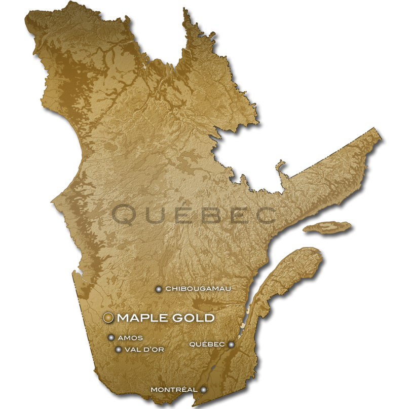
Figure 1: Province of Québec with Location of Maple Gold’s Douay/Joutel Gold Project
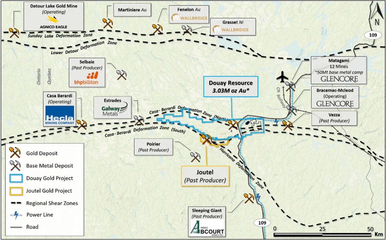
Figure 2: Plan map showing location of Douay Gold Project
Québec’s Mining Advantages:
- Québec is one of the world's most attractive mining jurisdictions, consistently ranked in the Fraser Institute’s Annual Survey of Mining Companies.
- The province hosts some of Canada's largest gold mining operations, including the Canadian Malartic mine (~150 km south), which shares geological similarities with Douay.
- Québec offers competitive tax incentives for exploration and development, with rebates of up to $0.37 per $1 spent on exploration.
Project Geology & Mineralization
The Douay deposit is situated within the northern Abitibi Greenstone Belt, a world-class Archean gold district. Gold mineralization at Douay is primarily hosted in a bimodal volcanic and intrusive sequence, dominated by syenitic intrusions and basaltic flows, crosscut by major deformation structures associated with the Casa Berardi Deformation Zone.

Figure 3: General Geology of the Abitibi Subprovince in Quebec with the location of Douay Gold Project, Casa Berardi Deformation Zone (CBDZ), and producing gold mines and camps.
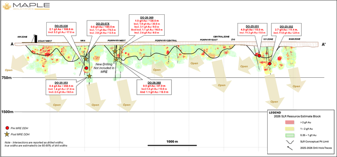
- Nika Zone: Syenite-hosted, broad, high-grade intercepts at depth; site of the 2025 step-out success (2.05 g/t Au over 108.6 m).
- Porphyry Zones (West, Central, East): Structurally-controlled, lower-grade, high-tonnage gold system comprising over 55% of current contained ounces.
- Central & NW Zones: Emerging areas of interest with higher-grade intersections and limited historical drilling.
- Taibi Target Area: Recently staked claims covering Taibi Group sedimentary rocks and banded iron formations north of the Douay resource area, representing a promising new exploration front along the projected northwest extension of the Douay Deformation Zone.
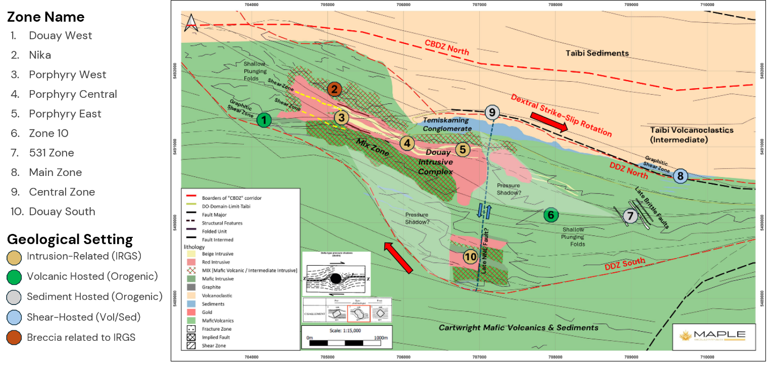
Figure 4: General Geology of Douay Gold Project showing outline of Douay Deformation Zone with potential strike-slip rotation generating pressure shadows around the Douay alkaline intrusive complex. Main mineralized zones are highlighted by geological setting.
Mineralization remains open laterally and at depth across all major zones, with particular emphasis now on bulk-tonnage underground targets beneath and beyond the current pit shells.Mineralization occurs as broad zones of disseminated and fracture-controlled gold within variably fenite-altered syenite, hydrothermal breccias, and intercalated volcanic rocks. Alteration assemblages include K-feldspar, amphibole, magnetite, quartz-carbonate, and chlorite, with 5–15% disseminated pyrite locally associated with elevated gold grades.
Nika Zone: Syenite-hosted, broad, high-grade intercepts at depth; site of the 2025 step-out success (2.05 g/t Au over 108.6 m).
Porphyry Zones (West, Central, East): Structurally-controlled, lower-grade, high-tonnage gold system comprising over 55% of current contained ounces.
Central & NW Zones: Emerging areas of interest with higher-grade intersections and limited historical drilling.
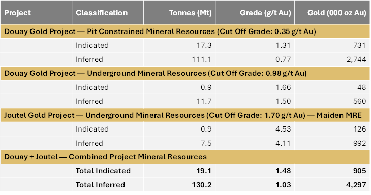
Mineral Resource Estimate (MRE)
The Douay Gold Project hosts an established NI 43-101 mineral resource estimate, comprising:
- Douay pit-constrained MRE (0.35 g/t Au cut-off grade): 731,000 Indicated gold ounces (17.3 Mt at 1.31 g/t Au) and 2,744,000 Inferred gold ounces (111.1 Mt at 0.77 g/t Au);
- Douay underground MRE (0.98 g/t Au cut-off grade): 48,000 Indicated gold ounces (0.9 Mt at 1.66 g/t Au) and 560,000 Inferred gold ounces (11.7 Mt at 1.50 g/t Au)
Further details on the key assumptions, parameters, and methodologies used in the resource estimate, along with potential legal, political, environmental, or other risks, can be found in the NI 43-101 Technical Report (SLR, 2026).
Table 1: Douay Project Updated Mineral Resource Estimate – April 24, 2026
Notes to the Mineral Resource Estimate:
-
CIM (2014) definitions were followed for Mineral Resources.
Mineral Resources are estimated using a long-term gold price of US$2,500/oz and a US$:C$ exchange rate of 1:1.35.
For Douay:- Minimum mining width of 3 metres applied to resource domain wireframes.
- Bulk density interpolated for Nika, Porphyry, and 531 zones; 2.72–2.88 t/m³ assigned to all other zones.
- Whittle pit shell: C$4.00/t rock mining, C$3.00/t overburden, C$12.50/t processing, C$2.86/t G&A, 90% recovery, 25° overburden / 50° rock pit slopes.
- Open pit resources reported within Whittle pit shell at elevated COG of 0.35 g/t Au; actual discard COG ~0.16 g/t Au.
- Underground resources reported at COG 0.98 g/t Au: C$80.00/t UG mining, C$12.50/t processing, C$2.86/t G&A, 90% recovery; includes low-grade blocks within constraining shapes.
-
For Joutel:
- Minimum mining width of 2 metres applied to resource domain wireframes.
- Constant bulk density of 2.85 t/m³ assigned to all mineralized zones.
- Underground resources at COG 1.70 g/t Au: C$120.00/t UG mining, C$25.00/t processing, C$20.55/t G&A, 90% recovery; includes low-grade blocks within constraining shapes.
-
Mineral Resources that are not Mineral Reserves do not have demonstrated economic viability. No Mineral Reserves have been estimated. There is no guarantee that any part of the Mineral Resources will be converted to a Mineral Reserve in the future.
Numbers may not add due to rounding. -
Effective date of the 2026 MRE is April 24, 2026.
Mineral Resource Estimate prepared by SLR Consulting (Canada) Ltd. QP: Denis Decharte, P.Eng., independent of Maple Gold. Ian Cunningham-Dunlop, P.Eng. (PEO/EGBC), EVP of Maple Gold, reviewed and approved all scientific and technical content as QP under NI 43-101.
Table 2: Comparison of SLR 2026 MRE vs. SLR 2022 MRE – April 24, 2026
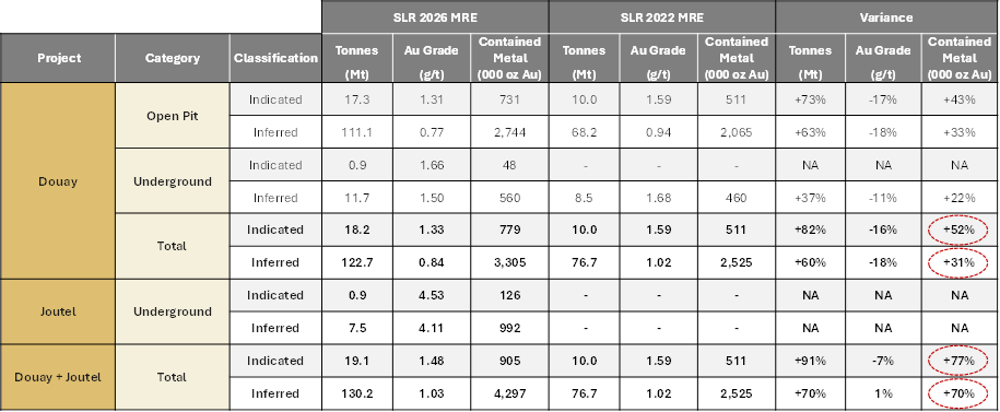
Notes:
- Listed Au grades and tonnes are shown for comparison purposes only; refer to table on preceding slide for the official Mineral Resource tabulation.
- Douay Pit-constrained Mineral Resources for the SLR 2026 MRE are reported above a 0.35 g/t Au COG compared to a 0.45 g/t Au COG for the SLR 2022 MRE.
- Douay Underground Mineral Resources are reported above a 0.98 g/t Au cut-off grade for the SLR 2026 MRE compared to a 1.15 g/t Au cut-off grade for the SLR 2022 MRE.
- The Whittle pit shell used to estimate Mineral Resources in the SLR 2026 MRE used a long-term gold price of US$2,500/oz and a US$:C$ exchange rate of 1:1.35 compared to a long-term gold price of US$1,800/oz and a US$:C$ exchange rate of 1:1.25 used in the SLR 2022 MRE.
- For additional details on the 2022 MRE, please refer to the Company's news release dated March 17, 2022, which can be found on the Company's website (www.maplegoldmines.com).
*Please refer to the Table 1 Notes for additional information. The Douay 2026 MRE is shown in bold.
Figure 1: Douay oblique view showing 2026 MRE block model, modeled open pit outlines, and selected drilling results not included in the 2026 MRE – Looking 045 Deg Azimuth
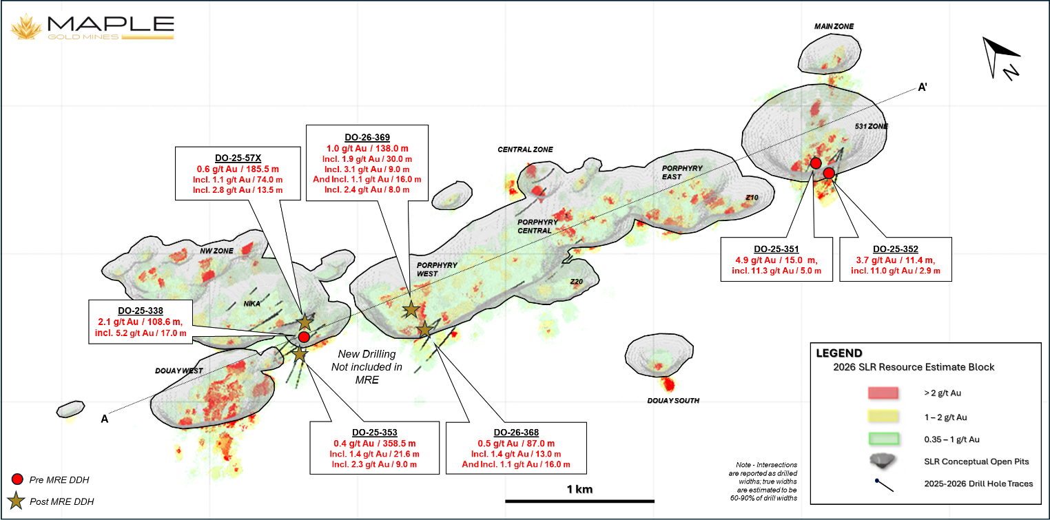
Figure 2: Douay longitudinal section showing distribution of 2026 MRE block model, modeled open pit outlines, and selected drilling results not included in the 2026 MRE – Looking 020 Deg Azimuth