


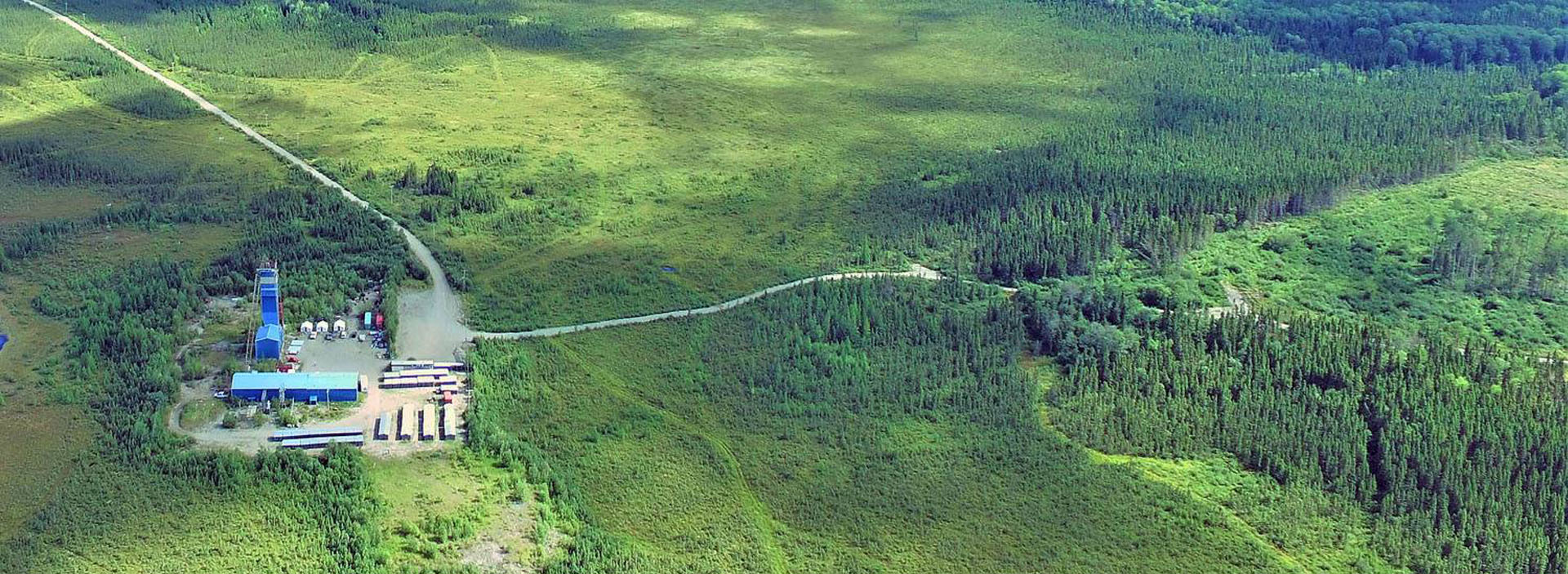
Douay Gold Project
The Douay Gold Project is a 100%-owned, district-scale gold project in Québec's Abitibi Greenstone Belt, one of the most productive gold regions in the world (Figure 1). Douay sits along the Casa Berardi Deformation Zone, the same structural corridor that hosts Orezone Gold Corporation's Casa Berardi mine and underlies the northern half of Maple Gold's ~481 km² Douay/Joutel land package (Figure 2 and Figure 3).
Douay hosts an established open-pit and underground mineral resource of 779,000 ounces of gold (Indicated - 18.2 Mt at 1.33 g/t Au) and 3,305,000 ounces of gold (Inferred - 122.7 Mt at 0.84 g/t Au), distributed across 12 mineralized zones over a six km strike length (Figure 4 and Figure 5). The deposit remains open along strike and at depth across every major zone.
What sets Douay apart is not just its size but its structure. Gold at Douay occurs in steeply plunging higher-grade shoots within a much larger, lower-grade system. Since 2025, Maple Gold has been systematically defining the geometry of those shoots and drilling them directly, an approach that has already delivered the project's best intercepts to date and opened up a substantial untested depth profile beneath the current pit shells.
Douay lies approximately 55 km south of Matagami, Québec, with year-round access from Provincial Highway 109, which cuts directly across the property. The project benefits from grid power nearby, established regional infrastructure, and access to a skilled local workforce, conditions that support low-cost, efficient exploration and, ultimately, development.
Joutel, Maple Gold's second 100%-owned project, is contiguous to the south and approximately 35 km away by road.
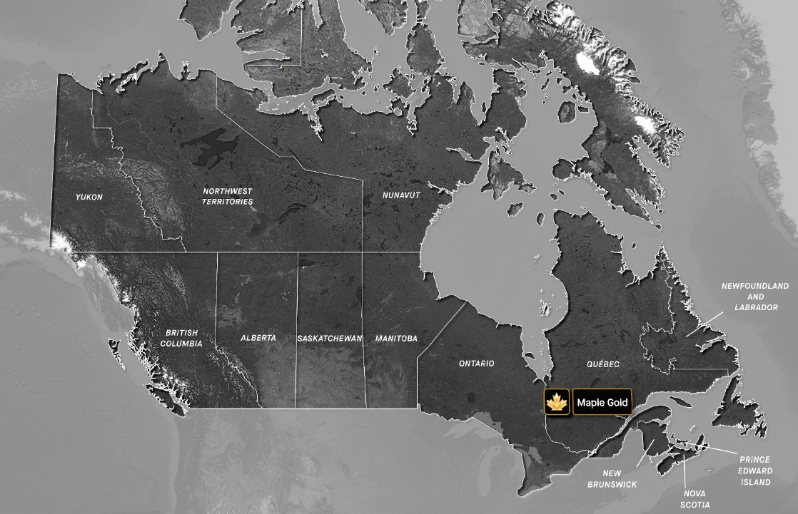
Figure 1: Location of Maple Gold’s Douay/Joutel Gold Project
Québec's mining advantages
-
Consistently ranked among the world's most attractive mining jurisdictions in the Fraser Institute's Annual Survey of Mining Companies
-
Home to several of Canada's largest gold operations, including the Canadian Malartic mine approximately 150 km to the south, which shares geological characteristics with Douay
-
Competitive exploration tax incentives, with rebates of up to $0.37 per $1 spent on exploration
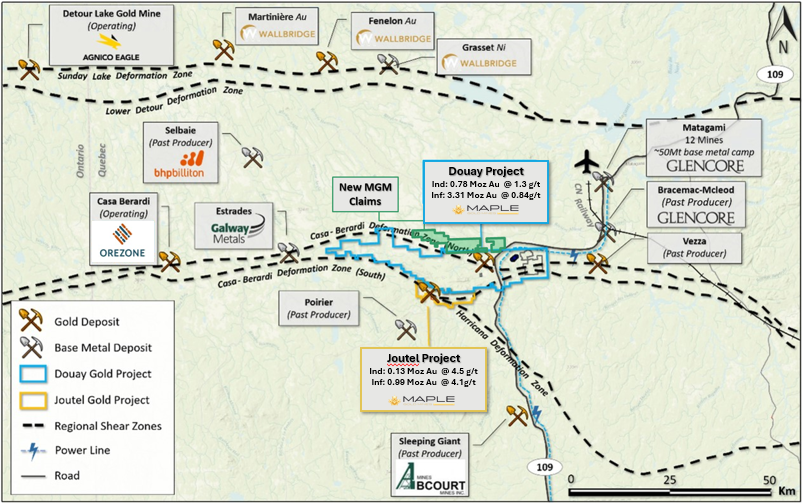
Figure 2: Plan map showing the location of Douay Gold Project
Douay sits within the northern Abitibi Greenstone Belt, a world-class Archean gold district. Gold occurs in and around the Douay Intrusive Complex, a large alkalic syenite body emplaced into a sequence of basalts and volcaniclastic and sedimentary rocks, and traceable over a 6 km corridor. The whole system is cut by structures associated with the Casa Berardi Deformation Zone.
Mineralization occurs as broad zones of disseminated and fracture-controlled gold within variably fenite-altered syenite, hydrothermal breccias, and the surrounding volcanic rocks. Alteration assemblages include K-feldspar, amphibole, magnetite, quartz-carbonate and chlorite, with 5 to 15% disseminated pyrite locally associated with elevated gold grades.
While the resource (as a whole) averages just over 1 g/t Au, multiple areas carry significantly higher grades, both near surface and at depth. These higher-grade zones sit within shoots that plunge moderately to steeply to the southeast and shallowly to the southwest, and Maple Gold's current interpretation is that these shoots repeat at intervals along strike — a model the Company is now applying systematically across the property (Figure 6).
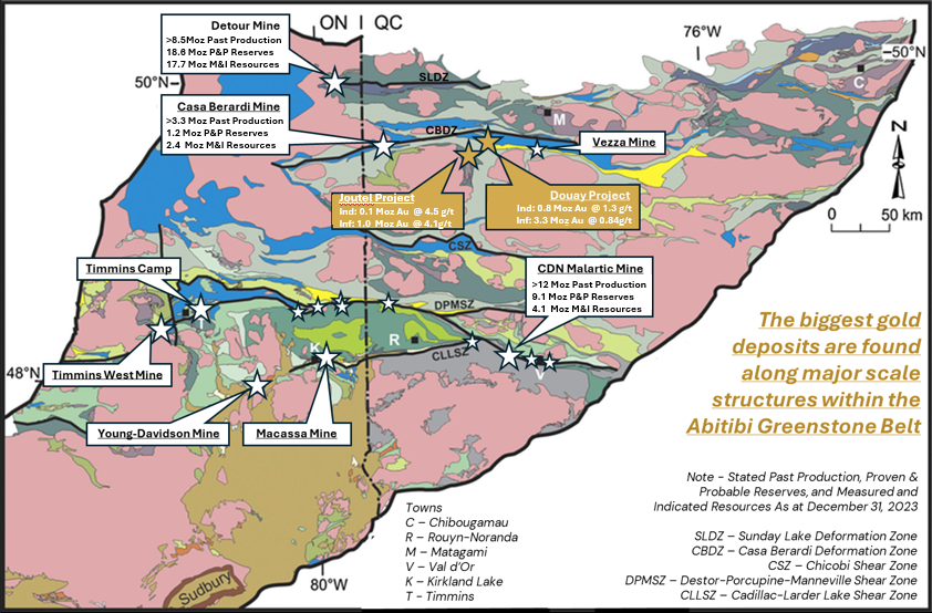
Figure 3: General Geology of the Abitibi Sub province in Quebec with the location of Douay/Joutel Gold Project, Casa Berardi Deformation Zone (CBDZ), and producing gold mines and camps.
Key zones
- Porphyry Zones (West, Central, East) — Structurally controlled, lower-grade, high-tonnage mineralization hosted by the Douay Intrusive Complex. Together these zones account for the majority of current contained ounces.
- Nika Zone — Syenite- and volcanic-hosted, with broad higher-grade intercepts at depth, including 2.05 g/t Au over 108.6 m in hole DO-25-338.
- 531 Zone — One kilometre east-southeast of the Porphyry Zones, hosted in mafic volcanic and folded sedimentary rocks. Hosts one of the highest-grade intersections reported at Douay to date.
- Z10 and Z20 Zones — Immediately south of the Porphyry Zones, hosted by basalt cut by syenite dikes.
- Douay West, North West and Central Zones — Emerging areas with higher-grade intersections and limited historical drilling.
- Taibi Target Area — Claims covering Taibi Group sedimentary rocks and banded iron formations north of the resource, along the projected northwest extension of the Douay Deformation Zone. An early-stage exploration front.
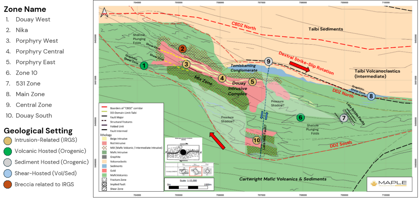
Figure 4: General Geology of Douay Gold Project showing outline of Douay Deformation Zone with potential strike-slip rotation generating pressure shadows around the Douay alkaline intrusive complex. Main mineralized zones are highlighted by geological setting.
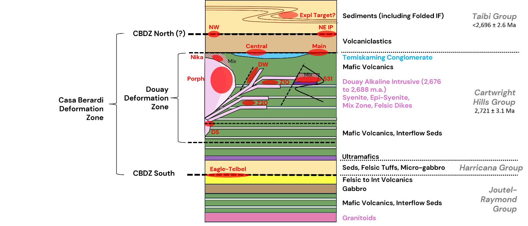
Figure 5: Schematic Stratigraphic Column of Douay/Joutel Gold Project showing the distribution of Mineralized Zones (in red)
Maple Gold completed 46 drill holes totalling 20,794 m at Douay during the 2026 winter program, the largest campaign in the Company's history. Drilling targeted the down-plunge extensions of the higher-grade Nika, 531, Porphyry, Z10 and Douay West Zones, tested a secondary shallow westerly plunge, and infilled gaps within the existing resource. These 46 drill holes are not included in the 2026 MRE and represent an opportunity for the next MRE update.
Recent highlights include:
- 1 g/t Au over 74 m, including 2.8 g/t Au over 13.5 m, in the Nika Zone
- 0 g/t Au over 138 m, including 3.1 g/t Au over 9 m, in the Porphyry West Zone
- 05 g/t Au over 108.6 m, including 3.05 g/t Au over 55.8 m, in the Nika Zone
(See news releases dated April 16, 2026, and April 3, 2025.)
Looking ahead, Maple Gold is refining targets for a full- funded drill program at Douay in the first half of 2027, weighted toward regional exploration alongside continued mineral resource expansion. Supporting work completed in 2026 includes a 1,347 line-km airborne gravity gradiometer and magnetic survey, regional sonic drilling in the Taibi Sediments, geotechnical drilling within the modeled open pits, and a core scanning pilot program across the Nika and 531 Zones.